Decades of Toxic Waste Dredged from the Duwamish
Seattle Times, March 22, 2014. By Erik Lacitis, Staff reporter
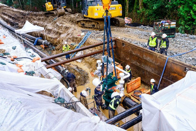
Waste from industry is being dredged up from the Lower Duwamish Waterway, dumped on barges, then onto rail cars, then moved to a disposal site in Klickitat County. By 2015, enough muck will have been hauled away to fill nearly 95 Olympic-size swimming pools.
Since last year, the locals who live in Georgetown and South Park have watched the cranes on barges scoop the dark, toxic dirt out of the Lower Duwamish Waterway.
Sometimes they can see pieces of corroded metal sticking out. All kinds of junk was dumped in the river.
After seemingly endless meetings and sheafs of documents, the Duwamish finally has been gettingcleaned up.
That 5-mile stretch was more polluted than any river in the state, says Shawn Blocker, a cleanup manager with the federal Environmental Protection Agency.
By 2015, they’ll have hauled out enough muck to fill nearly 95 Olympic-size swimming pools: 310,000 cubic yards.
Marianne Clark, 62, lives in a 100-year-old home in Georgetown.
“I hope that in my lifetime, my grandchildren can eat fish from there once again,” she says.
She and her husband, Chuck Clark, live in the two-bedroom, one-bathroom home on Carleton Avenue South that used to be her grandparents’.
Clark remembers regularly visiting and watching her grandma put some lard on a big, black skillet, and pan-frying the local fish catch.
Grandpa, uncles, her dad — they all used to walk to the Duwamish a few blocks away and cast their lines. Their haul would include perch, bass, sole, sometimes a salmon, she said. While her dad fished, sometimes Clark and other kids played in the sand. That was in the 1950s.
“Now it’s blackish, with murky water. It’s not a pretty sight,” Clark says.
Back then, there were no ominous warning signsthat there are now from the state’s Department of Health not to eat the bottom fish, and shellfish or crab. They’re written in English, Laotian, Russian, Hmong, Cambodian, Spanish, Chinese and Vietnamese. Still, there are reports the fishing continues.
Clark says about the deadly chemicals, “Nobody knew about it. We didn’t understand.”
It’s been a long time coming, this saving of the waterway.
The poisons that ended up in the river have been known for some time.
In 1945, a state report itemized what was being dumped, including:
• 500 pounds a day of acetylene generator waste from Todd Dry Docks and other sources.
• 200 to 250 pounds a day of “highly toxic chromic acid solution” from Boeing Plants 1 and 2. The acid was linked to “at least two fish kills.”
• 1,200 to 1,500 gallons of acid dip dumped monthly from National Steel Construction.
Nobody was “trying to be bad,” says Dan Cargill, the state Department of Ecology’s source control project manager for the Lower Duwamish.
He says, “There was no place to put the stuff. Nobody knew how to handle it. Everyone was keeping their fingers crossed.”
Mounds of paperwork
It can be mind dulling to wade through and understand paperwork from the EPA and other agencies about the Duwamish.
There are, for example, toxins called polychlorinated biphenyls.
That’s PCBs.
“I couldn’t tell you what kind of chemical it is,” says Gloria Jacquemart, 77, about PCBs. She has lived in South Park for 50 years.
But, she says about in past years watching the dirty liquid gushing into the Duwamish from pipes, “I knew it wasn’t plain water. I figured it was bad. But what could you do? It’s our livelihood.”
She was referring to the thousands of jobs, many of them in manufacturing, along the 5-mile waterway.
That section is called a waterway and not a river because beginning in 1913, that chunk of the meandering Duwamish was straightened out for industry.
The excavated dirt ended up being part of the man-made Harbor Island, which once held the title of world’s largest artificial island. These days, Flevopolder in the Netherlands, reclaimed from the sea, holds that honor at 375 square miles.
The Lower Duwamish Waterway served its purpose for a growing Seattle.
A 2010 report for King County said the area provided 106,000 jobs and generated $13.5 billion.
It wasn’t until three decades ago that real efforts began to rectify the damage done to the life of the waterway.
It was the PCBs in the sediment that caused the most concern. From 1929 until they were banned in 1979, they had hundreds of industrial uses. Hydraulic equipment, plasticizers in paint, electrical equipment, you name it. They were stable, nonflammable and had high boiling points.
But even when banned, PCBs didn’t disappear. Because they don’t break down easily, they linger in the environment. That made people who ate the fish, especially pregnant and breast-feeding women, and their babies, particularly vulnerable.
Usha Varanasi, a biochemist, was part of a team that in the 1980s did one of the early studies about how bottom fish in the waterway were affected.
She is the retired science director of the National Oceanic and Atmospheric Administration’s Northwest Fisheries Science Center.
“Mother’s milk is very fatty, and so the baby is getting a pretty good dose of PCBs. Babies are just developing. Even small amount of PCB can cause problems,” says Varanasi. “Young babies may not die, but they could grow into individuals who are more susceptible to illnesses.”
The EPA says the chemical is probably cancer causing in people, and is associated with a host of other bad effects, from short-term memory loss to affecting the immune system.
Highest risk at T-117
And so on a recent morning, work continued at a site by the Duwamish called T-117, for the Port of Seattle’s Terminal 117, near Dallas Avenue South and 17th Avenue South.
When you talk pollution on the waterway, this was one of the nastier places.
The Port now owns the site, but for 60 years beginning in 1937, it was where asphalt roofing was manufactured, first under the name Duwamish Manufacturing, and then as Malarkey Asphalt.
Back in 1991, the state did a hazard ranking and, on a scale of 1 to 5, the asphalt site reached No. 1. That’s the highest risk to human health.
Even after its buildings and tanks were torn down and hauled out, a 2004 Seattle Times story noted: “A thick, hardened flow of oily asphalt still oozes to the river like lava from a Hawaiian volcano.”
The Port says the plan is to turn the 3½-acre site into public space, with a trail, a hand-carried boat launch, a pier.
Looking directly across the waterway from T-117, to where the now-demolished Boeing Plant 2 used to be, you can see how such a turnaround would look.
On the far shore, small vegetation has recently been planted. In total, says Boeing, more than 170,000 plants are in this new, clean soil.
An integral part of local history used to be at this location — the 1.7 million-square-foot plant where such historic planes as the B-17 Flying Fortress were built in World War II, continuing on to the first 737s in the 1960s.
During the war, the company had put its electrical transformers under the main floor in case the plant was bombed. When the transformers were serviced, chemicals went down the floor drain. And into the waterway.
John Guevarra, 85, who lives in South Park, worked for 25 years at that plant “and pretty much every plant.”
“The whole process of treating metals, all that stuff got spilled into the river,” he remembers. “I don’t know how crabs and little buggies survived in that river. I guess they’re a hardy group.”
Plant 2, along with T-117, is among five hot spots that the EPA, in its Superfund designation of the waterway, has set for early cleanup.
Boeing says it will have spent more than $100 million on dredging and shoreline cleanup that began in 2013 and that it expects to conclude next year.
The dredging this year is wrapping up as the salmon runs are about to begin.
Because the salmon move swiftly through the contamination, they’re deemed OK to eat.
Dirt hauled away
Meanwhile, a tugboat moves the dirt-laden barges to the Lafarge cement plant a little more than 3 miles north on the waterway.
There, the toxic soil is loaded onto containers that end up in rail cars hauling it to Klickitat County, to an arid location at Republic’s Roosevelt Regional Landfill.
At 915 acres, it is one of the largest landfills in North America, in an area with a thick clay layer. It is federally approved to take in such soils.
In any case, the dirt is gone.
From time to time Marianne Clark walks the few blocks from her home to the waterway and sits on a bench there.
“Sometimes I watch the sunset. It’s beautiful. You see Mount Rainier and everything,” she says.
As for her grandchildren being able to fish the Duwamish, after this initial phase, says the EPA, it’s expected that PCB levels will be half what they used to be.
More work is planned on the rest of the waterway.
“Will there ever be completely unrestricted fishing there?” says Cargill, of the state Ecology Department. “I don’t think we’ll ever get there.”


